As a landowner in North Texas, you possess a valuable asset. But what truly separates a dormant parcel of raw land from a lucrative development opportunity? The answer lies in a handful of critical factors that every developer scrutinizes before they ever consider making an offer. Many landowners, unaware of these key criteria, sell their property prematurely, leaving significant value on the table for the next owner to unlock.
Understanding what makes land developable is the first step toward maximizing your financial return. It’s not just about acreage; it’s about feasibility. This guide will walk you through the essential elements that determine your land's true potential, empowering you to see your property through the eyes of a developer. At Land Partner Group, we specialize in navigating this complex landscape, ensuring landowners like you capitalize on the full, entitled value of their property, not just its raw value.
The Foundation of Feasibility
Before a single blueprint is drawn or a shovel hits the ground, a developer conducts a thorough feasibility study. This process is a critical investigation into whether a project is practical, possible, and profitable. They are looking for a clear path to entitlement—the legal process of securing approvals from government entities for the right to develop a property for a specific use. A property with a straightforward path to entitlement is exponentially more valuable than one with numerous obstacles. The core question they ask is: "Can this land be transformed into a finished community or commercial project in a reasonable timeframe and for a reasonable cost?" The following factors are central to answering that question.
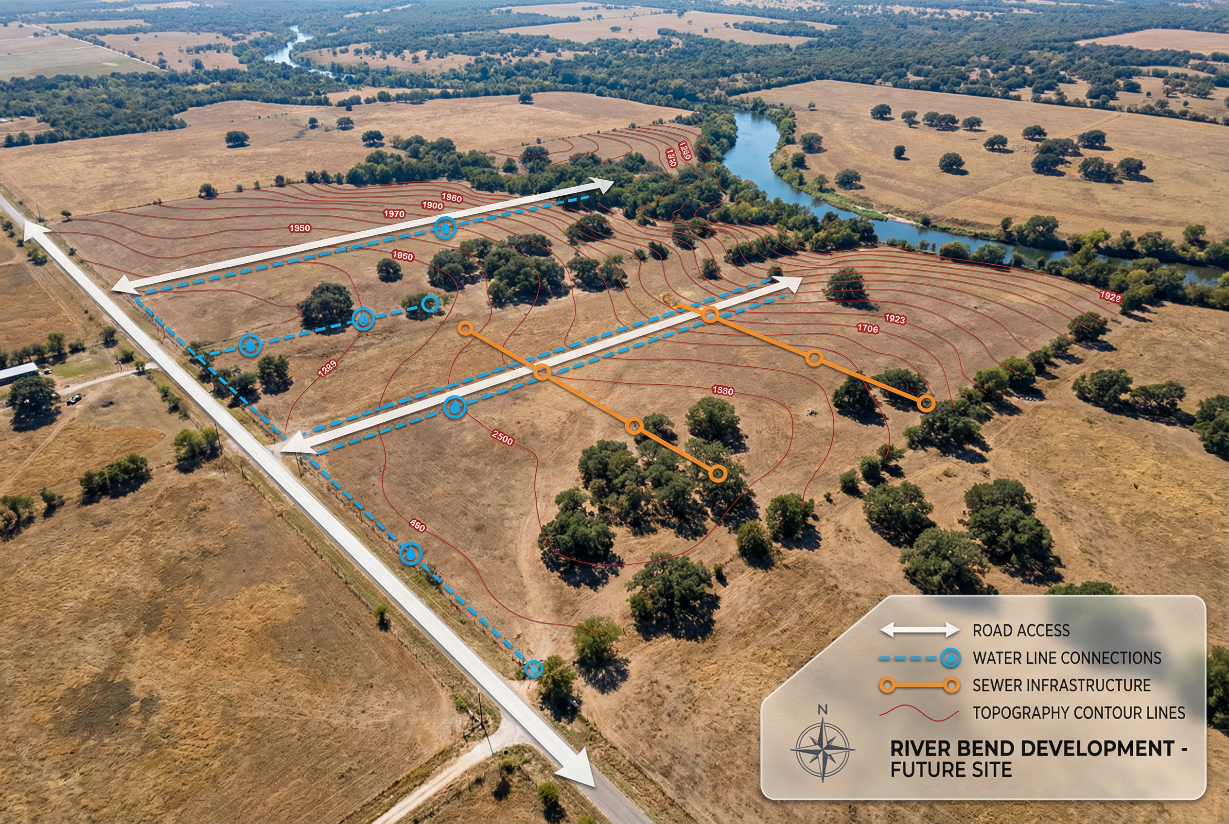
Factor 1: Road Access and Frontage
The most fundamental requirement for any development is access. A property must have legal, physical, and practical access from a public road. Without it, the land is effectively landlocked and, from a development standpoint, nearly worthless. Developers look for ample road frontage—the length of the property boundary that adjoins a public road. This is crucial for creating safe and efficient entrance and exit points for the future community or commercial center.
Why Frontage Matters
- Ingress and Egress: A development needs well-designed entrances that can handle the traffic volume of hundreds or thousands of future residents. Limited frontage can create bottlenecks and safety hazards, often leading to a project denial by city transportation departments.
- Visibility and Marketability: For commercial projects, frontage on a major thoroughfare is paramount for visibility to potential customers. For residential projects, a well-defined entrance enhances the community's curb appeal and perceived value.
- Utility Easements: Road frontage often provides a ready-made corridor for extending public utilities like water, sewer, and electricity to the site, which we'll discuss next.
A property with generous frontage on a county road or state highway is significantly more attractive than one accessed by a narrow, private easement. When evaluating your land, consider not just that you can get to it, but how a future community of hundreds of homes would get to it. This is a core principle in determining how developers value land.
Factor 2: Utility Availability (Water and Sewer)
Modern life runs on utilities. For a residential or commercial development, access to municipal water and wastewater (sewer) services is non-negotiable. A property might be beautiful, but if it’s miles from the nearest utility lines, the cost to extend those services can kill a project before it starts. Developers will map the proximity and capacity of existing water and sewer mains. "Proximity" is key. Having a sewer line a mile away is not the same as having it at your property line.

The Cost of Connection
Extending utility infrastructure is incredibly expensive. Costs can run into the hundreds of thousands or even millions of dollars, depending on the distance, terrain, and pipe capacity required. This cost is factored directly into the developer's financial model and, consequently, the price they are willing to pay for the land. If the extension costs are too high, the project becomes financially unviable. This is why a partnership approach, where these costs are managed as part of the overall land entitlement process, is often the only way to make a project work on the fringes of existing development.
Factor 3: Topography and Floodplains
The physical characteristics of the land itself play a massive role in its development potential. Developers prefer land that is relatively flat and well-drained. While rolling hills can create a beautiful aesthetic, steep slopes, rock outcroppings, and dramatic elevation changes increase construction costs significantly.
Many landowners sell too early, unaware that a strategic partnership could solve these physical constraints and unlock the land's full development value.
The Floodplain Problem
One of the biggest red flags for a developer is the presence of a designated floodplain. Areas within a 100-year floodplain are subject to strict federal (FEMA) and local regulations that severely restrict or forbid construction. Developing in or near a floodplain requires extensive and costly engineering solutions, such as raising the entire site with fill dirt or building large detention and retention ponds. This not only adds enormous expense but also reduces the net buildable area of the property, directly impacting the number of lots that can be sold. A property with a significant portion in a floodplain is inherently less valuable than a similar-sized parcel with no such constraints.
Factor 4: Current Zoning and Future Land Use Plans
Zoning is the set of local laws that dictates how a property can be used. Common categories include agricultural, residential, commercial, and industrial. A developer must ensure that their proposed project aligns with the property's current zoning or have a high degree of confidence that they can successfully rezone it. For example, you cannot build a subdivision on land zoned for agricultural use without first getting the city to approve a change to residential zoning.
Equally important is the city's Future Land Use Plan (FLUP). This document outlines the city's long-term vision for growth. If a developer wants to rezone a property from agricultural to single-family residential, and the FLUP designates that area for future residential growth, their chances of success are much higher. Attempting to rezone a property in a way that contradicts the FLUP is an uphill, expensive, and often impossible battle. A savvy developer, or a partner like us, will analyze both documents to gauge the political and regulatory risk associated with the entitlement process.
How to Assess Your Land's Potential
As a landowner, you can begin a preliminary assessment yourself. Use online county appraisal district maps to check for floodplains. Visit your city's planning and zoning department website to find zoning maps and the Future Land Use Plan. Measure your road frontage on an aerial map. However, this initial look only scratches the surface.
A true understanding of your land's development potential requires a professional feasibility study. This involves civil engineers, land planners, and legal experts who can analyze utility capacity, conduct topographical surveys, and navigate the complex political landscape of municipal approvals. This is the work that separates raw land from an entitled, shovel-ready project. It is this process that creates the enormous uplift in value that most landowners miss out on.
Don't Sell Yourself Short
The difference between raw land value and entitled land value can be staggering. By selling your property directly to a developer, you are essentially letting them capture all the value created through the entitlement process. A partnership approach is different. By partnering with an expert like Land Partner Group, you retain ownership while we invest the capital and expertise to navigate the complexities of access, utilities, zoning, and engineering. We manage the entire process, transforming your property into a fully entitled, high-value asset. Only then do we market it to our network of top-tier homebuilders, ensuring you receive the maximum possible return.
If you own 20 or more acres in North Texas and want to understand the true development potential of your property, the next step is to talk with us. Let us show you how a strategic partnership can unlock its hidden value. Explore the possibilities by visiting our partner page to learn more about our process and how we can work together to achieve the best possible outcome for your land.